

| Adjacent Waterways . . |
| Upstream . . |
| Athlone to Portumna |
| IWAI Lough Derg Branch |
Waterway Walks
Index of Walks – Lough Derg
Walks by Lough Derg in downstream sequence:
Maps:
Office of the Admiralty
– Chart 5080. 1843. Lough Derg.
CAUTION: This chart has not been corrected since first date of publication and should be used with caution.
Ordnance Survey of Ireland, Discovery Series 1:50,000
– Map 53, Shannon Harbour to Illaunmore on Lough Derg
– Map 58, South-west Lough Derg from Mountshannon to Killaloe
and south to Ardnacrusha and Parteen
– Map 59, Central Lough Derg including Williamstown,
Dromineer, and Garrykennedy
The need for three OS maps contrasts with the excellent situation on the Erne where each of the lakes is covered by a single 1:25000 series map i.e., a total of two maps covers two large lakes. The maps of Lough Erne provide significantly more detail including submarine contours and navigation details. Hopefully a map of similar quality covering Lough Derg will be published shortly
| Portumna Forest Park * * * * |
|
Up to 10 km; 2.5 hrs; Start: Map 53 M854036 On paths and forest roads. Forest park. Historic, flora and fauna. |
| Portumna Forest Park provides extensive walks and includes Portumna Castle. Use Map 53 or locally available guide books to plan an interesting walk along lakeside and forest paths. | ||

| Lough Derg Way by Dromineer * * |
10 km; 2.5 hrs; Start: Map 59 R814862 On roads and lakeshore paths. Pleasant country walk. |
|
| A delightful circular lakeside walk along the first few kilometers of the Lough Derg Way. Visit the page. | ||
| Sli Eala by Dromineer * * |
10 km plus; 2.5 hrs plus; Start: Map 59 R814860 A walk of discovery by road and riverbank. Historic. |
|
| Sli Eala (Swan Way in Irish) links the historic lakeside village of Dromineer to the picturesque bridge and wier at Ballyartella. Set in the heart of Tipperary Lakeside, the route passes through an area of natural beauty with history and ledgend at every turn. The walk for part of its length follows the meandering Nenagh River (An Ghaothach). This river is home to many Mute Swans which give the walk its name. Visit the page. | ||

| Dromaan and Williamstown * * |
8 to 23 km and 2 to 6 hrs; Start: Map 59 at Williamstown Harbour (R781884) or Dromaan Harbour (R779881) Scenic rural walks on country roads. Lake views. |
|
| The Dromaan and Williamstown Walk is based on the walks described in the pamphlet Walks in the District of Whitegate published by East Clare Way Limited. The walk includes a number of options, and may be started at Dromaan Harbour or Williamstown Harbour. Depending on the combination chosen, the length of the walk can be as little as 8 km and 2 hrs or as much as 23km and almost 6 hrs. Visit the page. | ||
| Scariff and Tuamgraney * * |
Up to 19 km and 6 hrs; Start: Map 58 R643845 Scenic rural walks on country roads. Panoramic views of lake and Scariff region. |
|
The East Clare Way Limited has developed a number of circular walks. These start and finish at towns and villages along the East Clare Way. Five walks are described that start in the centre of Scariff (R643845). Tuamgraney quay (R643834) is a good place at which to start two of the walks:
See also the notes about the Brian Boru Oak included below ‘Other Suggestions’. |
||
| Inishcealtra (Holy Is.) * * * |
Up to 1 km; 0.25 hr; Start: Map 58 R697853 Across fields; Historic – Monastic |
|
| One of the more interesting ecclesiastical sites on the Shannon. An enjoyable and peaceful place to visit on a bright fresh day with a light breeze blowing. Only accessible by dingy. Anchor to east or west of the island. Do not attempt to take a cruiser through the channel to the north of the island.
To fully enjoy a visit to Holy Island read one of the short descriptions of the island’s history that are included in many books and guides about the Shannon and study a map of the island. |
||
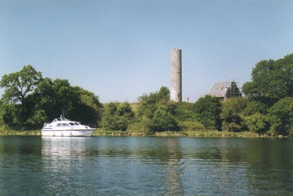
Iniscealtra
| Mountshannon * * |
Up to 16 km; 4 hrs; Start: Map 58 R712868 Scenic rural walks mostly on roads. |
|
The East Clare Way Limited has developed a number of circular walks. These start and finish at towns and villages along the East Clare Way. Five walks are described that start at Mountshannon:
|
||
| Aughinish Point * * |
Up to 8 km; 2 hrs; Start: Map 58 R705826 On paths and roads. Attractive rural walk. |
|
| The start of this walk is at Bunglasha Bay. This is close to a very treacherous part of Lough Derg. Hence this walk should only be contemplated in good settled weather. Approach carefully paying attention to the Admiralty Chart and being conscious of when it was last updated. Having anchored proceed ashore in the dingy.Various walks are possible. One possibility is to follow the path around Aughinish point and follow the road to Ogonnelloe. (R692818). Then head north along the road to the bay south east of Piper Island. From there follow the lakeside path back to Bunglasha. Shorter walks are obvious from the map.
East Clare Way Limited have published a pamphlet Walks in the Ogonnelloe District. The walks described in the pamphlet are adjacent to the walk outlined in the previous paragraph. A link to a copy of the map in the pamphlet is provided in the right-hand column. It is planned to add descriptions of the walks to the site. |
||

At Bunglasha Bay
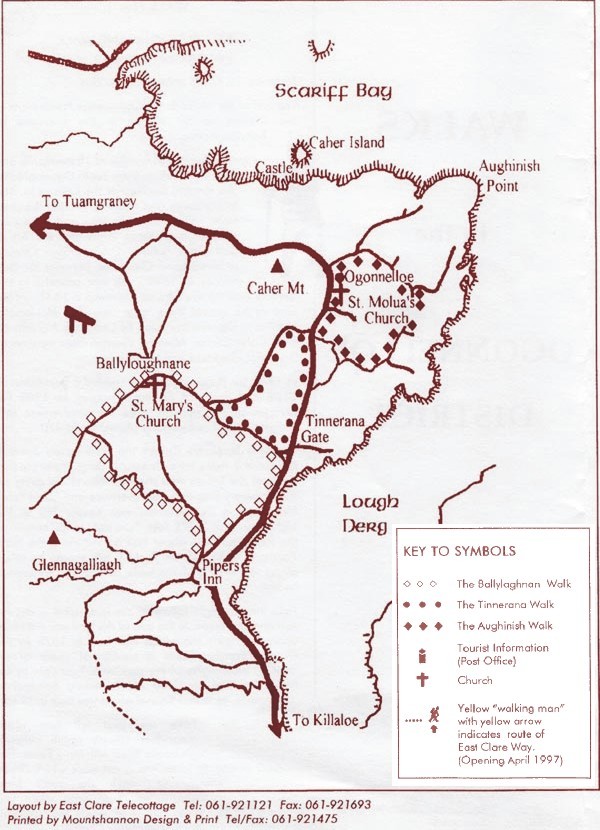
Walks in the Ogonnelloe District
Map published by
East Clare Way Limited
| Rinnaman Point |
|
Up to 7 km; 1.75 hrs; Start: Map 58 R687764 Scenic rural walks mostly on roads. |
The walks at Rinnaman Point (known locally as Two Mile Gate) page includes descriptions of two walks developed by the East Clare Way Limited. The walks that start at the Point are:
|
||
| At Killaloe * * |
Up to 24 km; 6 hrs; Start: Map 58 R704730 Attractive walks on rural roads. |
|
The walks at Killaloe page includes descriptions of three walks in the district developed by the East Clare Way Limited:
|
||

At Killaloe
Other suggestions:
Circular walks at Garrykennedy, and Terryglass.
A review of the maps will identify a number of circular walks, mostly on-road, starting at these harbours. The starting points are:
- Garrykennedy Map 59 R767839.
Opportunities for circular walks from the Quay, of which there are many, include walking on-road sections of The Lough Derg Way.Those interested in walking to the top of the highest hill in the area may like to follow the Lough Derg Way west from the Quay as far as Tountinna (457m) (R736774). From Tountinna retrace one’s steps the short distance downhill to the junction almost 200 metres below at R735780. Turn right and return to the quay via Portroe (R769815). This is a walk of about 18km/6 hours.It may be possible to incorporate some of the paths through the woods at Parker Point into a circular walk. That possiblity is on the ‘to be researched’ list. - Terryglass Map 53 M862010.
Thanks to Brian Goggin for suggesting the Garrykennedy and Terryglass possibilities and to Jim Murray for progressing the interest in walks at Garrykennedy.
These walks are on the ‘to be researched’ list. Comments on these suggestions please to webmaster@iwai.ie
Brian Boru Oak ![]() 7 km; 1.75 hrs; Start: Map 58 R644834.
7 km; 1.75 hrs; Start: Map 58 R644834.
On roads and forest paths.
This walk existed in 1992. At that time it was a delightful woodland walk. The walk commenced at Tuamgraney Quay. We walked to the village, turned left at the main road and continued a short distance along the road to a Heritage Center. The route started close to the Heritage Center on the opposite side of the road. My notes indicate that the location of the Oak is about R660830.
One Sunday afternoon in September 2000 we visited Tuamgraney with the intention of walking to the Oak following the largely circular route we walked in 1992. We had a most disappointing experience. Management of the woodland had changed and it had become a walk for pioneers and frontiersmen. We encountered forest roads that were difficult to walk on. Old woodland paths marked on a 1992 map of the walk were difficult to find. A lodge by one of the forest tracks had fallen into a state of disrepair. Unfortunately the Heritage Center was closed so we do not know of any plans to restore the woodland to its former state.
Please send comments on developments in the woodland to webmaster@iwai.ie
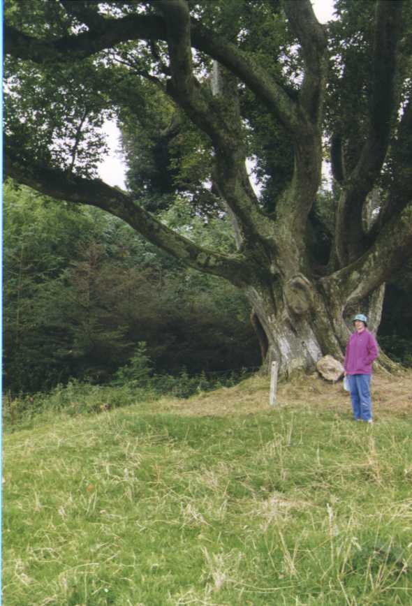
Brian Boru Oak near Tuamgraney

Evening on Derg